
The RCB Library's Archive of the Month takes another delve into the Diocesan Records of Tuam, Killala and Achonry (D5 & D5A), this time focussing on its extensive collection of maps and plans. The collection, which covers the period from c1613 to 2000, includes a vast arrange of primary sources and unique items that expound the religious fabric of a huge geographical area of the western part of Ireland – specifically all of county Mayo, and much of counties Galway and Sligo, as well as a small portion of county Roscommon.
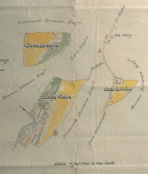 |
| Click image for enlarged view |
The maps and plans have been systematically arranged and a detailed catalogue-list is now available displaying over 80 maps, including some duplicates, showing either parish or district boundaries, and divided into four distinct categories.
While the maps span nearly four centuries, the earliest being a map of Kilmactigue in county Sligo from 1754), the majority date from the 1850s to 1873, a time when land was at the forefront politically and culturally in Ireland. This period represented a period of transition for the Church of Ireland, including its Disestablishment from the state on 1 January 1871.
The Library has digitised the drawing component of the collection because of the rich visual content, making it freely available to a worldwide audience.
Another important factor in prioritising this collection for digitisation was the fragile nature of some of these maps, whether due to age or in many instances the fact that they were drawn on thin tracing paper. The rich descriptive information that can be seen in the detailed catalogue-list has been incorporated into the digitised collection, allowing for the material to be easier to find by researchers and those with an interest in the area.