
The Royal Irish Academy recently provided an update on its Irish Historical Towns Atlas (IHTA) project, which I confess to being a great fan of. Not only are the historical maps excellent, but the story of how each featured town developed provides an understanding of the changing environment our ancestors experienced during their lives.
Although restricted, work on the IHTA project during the pandemic has continued, and we have many more atlases to look forward to in the not-too-distant future.
Next in line for publication, after many years of intense research, will be Cork City, by Howard Clarke and Máire Ní Laoí.
It will be the largest Atlas to date, and has been progressed in a partnership with Cork City Council. Like all previous atlases, it will offer thematic maps and photographs, an early nineteenth-century plan at the scale of 1:2500 (these show the pattern of housing plots before industrialisation and other development), maps showing the towns’ surroundings, and a modern town plan.
It will be accompanied by an explanatory text and historical gazetteer.
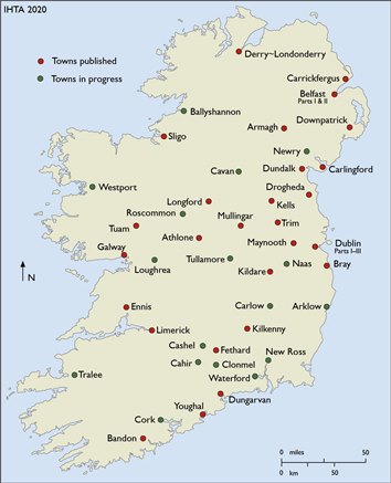
The number of atlases currently underway has grown, too. At various points of the production process are the following: Tralee (Marc Caball), Cavan (Jonathan Cherry/Brendan Scott), New Ross (Linda Doran), Tullamore (Michael Byrne), Ballyshannon (Angela Byrne), Clonmel (David Fleming), Westport (Eamon O’Flaherty/Siobhán Sexton), Arklow (Jim Rees), Waterford (Eamon McEneaney and Donnchadh Ó Ceallacháin).
Other towns more recently in progress are Cahir, Carlow, Cashel, Naas, Newry and Roscommon.
Click the map above for an enlarged view of the towns and cities already published and those still to come.
The most recent Atlas – published in October last year – was Rathmines, by Séamas Ó Maitiú. It joined Colm Lennon's Clontarf, which was reprinted last month, in the Dublin Suburb Series of the IHTA. This series is published in a revised but complementary format with numerous historical and modern maps, illustrations and photographs as well as an accompanying essay and individual histories of topographic sites in the featured town.
Next to appear will be Drumcondra (Ruth McManus), Kilmainham/Inchicore (Frank Cullen) and then Ringsend/Irishtown. This series is part-funded by Dublin City Council.
I can claim an ancestral connection to at least three of the towns/cities in the IHTA 'pipe', so I better start saving my shillings!