
The Archive of the Month from the RCB Library for March shines a spotlight on a beautiful map that makes up part of Ms 1104, a recent addition to the Library’s extensive manuscript collection.
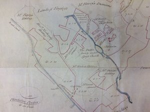 |
| The map of Glasnevin that accompanies the deed. RCB Library Ms 1104/8 |
Much like the Lindsay collection of which it is a part, the map is an important document for historians as well as for genealogists researching family members who lived in the area at this time. It provides visual cartographic evidence that predates the Ordnance Survey maps for this area, in which detailed lists of landowners or tenants who lived in this area at the beginning of the 19th century are included.
It was located with a deed dated 22 October 1833 between Hon Rt Revd Charles Dalrymple Lindsay (1760-1846), Dean of Christ Church Cathedral and Bishop of Kildare from 1804 until his death, and William John Gore of Dublin. It was surveyed by John Longfield in 1807
The map is focused primarily on the area surrounding Glasnevin village, incorporating areas that would be familiar to Dubliners today, such as Cross Guns, as well as references to Drumcondra to the east and the ‘Lands of Finglass’ towards the north.
What is striking is what is not visually depicted. For example, although the Botanic Gardens were founded here in 1795, the only reference that the map makes to its presence is a plot of land labelled ‘The Dublin Society under Christ Church’.
Click the map for an enlarged view.