
It is an interactive map that allows users to explore the urban heritage of the town of Dungarvan in County Waterford and is based on research and cartography carried out for the forthcoming RIA release Irish Historic Towns Atlas, no 30, Dungarvan/Dún Garbhán by John Martin (publication due in October).
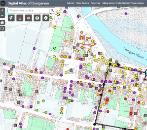 |
| Click image for larger view, theme and layer list |
Freely available and accessible online, the Digital Atlas of Dungarvan provides layers of historical Ordnance Survey maps that show how the town has changed over time. A specially digitised base map shows the town in 1841, where detailed historical information on some 650 individual sites has been incorporated.
If you have ancestors from the town, you'll be among those wanting to check out these details. Start with the Story Map, which is published alongside the atlas, and shows you how to investigate and enjoy the Digital Atlas of Dungarvan.