
 |
| Click to view page |
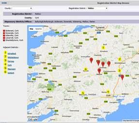
The Registration District Map Browse tool allows researchers to view a Google map of registration districts with each of its respective dispensing districts highlighted with red markers, as well as its adjacent districts highlighted by yellow markers.
If you click the image to the right, you'll see the Registration District map for Mallow, chosen from a list of 19 districts in County Cork.
The map shows the centred location of the area's six dispensing offices/districts (Buttevant, Doneraile, Killawillin, Liscarroll, Mallow and Shanballymore), and the six Registration Districts surrounding the area (Kilmallock, Mitchelstown, Fermoy, Cork, Macroom and Kanturk). All of the markers are linked to the corresponding map, and, being a Google map, you can zoom in to see more localised placenames, or even switch to satellite view.
"Existing registration district maps usually show just the district borders and sometimes the county, but they don't make it easy to see the towns and settlements within or near the districts," Shane told Irish Genealogy News. "With this browse tool, the list and location of neighbouring districts can be helpful to researchers who may need to widen their search area."
In time, Shane is also hoping to overlay district borders onto his 1867 map of Ireland, and may incorporate it with the Registration District Map search options.
Check out the Registration District Map Browse tool here. It's another handy visual aid for researchers on the swilson.info website, which is continuing to grow at a good pace. Set aside some time, if you can, to explore all the free aids provided.